


Although we have been using Google Maps for years and with other GPS navigation systems that claim to prevent us from getting lost when driving on the roads or walk through the city or towns, it is not difficult, even so, that we continue to get lost.
There are certain ways of talking about our friend who is the protagonist of Google Maps that can be confusing (such as when a trip starts by telling us to go to the southwest, as if we were compasses) and there are functions that have come out over the years and that we do not always know, but what They are there to make life easier for us..
In this article we are going to learn ways to get the most out of Google Maps and avoid getting lost.
‘Sgroogled.com’: when MICROSOFT launched ANTI-GOOGLE ads
Stop signs and traffic lights
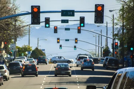
When our friend from Google Maps says that in “I don’t know how many” meters to turn left or right, we can get confused. How many of us know how to calculate hundreds of meters, even more so if we are driving? Another way to tell us where to turn is to tell us the name of the street, but it is not always indicated and, even if it is, we cannot stop to look at the sign that tells us what the street is called.

Well, having on the map the function, announced this year, of indicating in the view of the streets stop signs and traffic lights it will be easier to have references in our navigation. Thus, instead of counting meters (something much more complicated), just you have to count traffic lights. If you see on your Google Maps that you have to turn after the second traffic light, then you do it in person (also, this is an indication that we would calmly give to another person when we want to help them get to a place).
Follow your route in detail
You can manually check where the blue line that marks a route passes, but there is also this function automatically. If you touch the Steps button in the preview of a route or selecting Directions, it gives you the information in a very visual way. It is a quick way to check the next steps of a route without having to swipe manually the course to follow the blue line on the map.
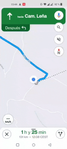
To see it visually when you are already on the route, you can press the routes button (on the left, with a forked path icon), although if you just want refer to the following indications, you can slide the top bar to the left, which shows you the next output.
Find services near your road

Before falling into the possibility of taking an exit on the motorway indicated by a sign and that rIt turns out that that gas station is a while further from the fixed pathyou can look at what gas stations are on the road to see which ones are closest to you (and also the price at which gasoline is set in each of them, something very interesting with the current situation).

When you have your trip marked, search on the Gas Stations button that you have in the quick search row below the search bar. You can also search for the word gas stations by hand, or go to the options of those quick buttons. And, after this, on the map will be marked with a red icon with their symbol. You can click on the See list button or manually browse the map to see all the gas stations around you.
Download Maps in case you lose connection
If you are going to travel to remote areas of the world or go to other countries where roaming does not arrive, you could be left without an Internet connection. It’s recommended that download maps from Google Maps for offline use. It’s very simple.

First click on the button with your avatar on the top right; when you enter the menu, click on Offline Maps; Choose Select your own map; with your fingers zoom in or out the image to exactly locate the area what interests you. Hit the download button.
Activate augmented reality
This is if you are going to move from one place to another on foot. You can use Google Maps augmented reality navigation. It is a navigation method that Google has with the idea of helping you to better guide you on your journeys if you do not have enough with conventional navigation. Not all mobiles have it, although more and more brands have integrated it.
With this system, you will point your mobile forward, and thanks to its camera you will see the streets in front of you on the screen. Google Maps will then display the navigation signs on the on-screen street image as if they were right in front of you. Thus, instead of dealing with a map to calculate the streets, You will see the directions you need to get to your destination on the street you are walking on..
Understand what the voice of the app means
There are certain things that the app’s voice explains that can sometimes be confusing. If you use it often, you will begin to understand its expressions and the typical mistakes it can make. In the case of errors, when you are on a winding road, it may happen that Google Maps tells you: “turn right”, when really you just have to continue on the same road that has a big curve to the right. Do not try to find an alternative road and turn around, because you may get lost.
![]()
At forks, Google Maps tells you if you have to stay in the left or right or center lane if there is one. And, therefore, sometimes when what seems to be an exit to the side, Maps tells you that you have to stay in a certain lane. If, for example, you see that there is an exit to the right, while the left lane is going straight and tells you to keep to the right, it probably means to take that exit.